Red Rocks Canyon Open Space
In this article I focus on my two favorite trails in the central part of the open space: the Red Rock Canyon Trail and the Greenleaf Trail.
I will also mention some other trails that connect with these two trails to create loop hikes of varying lengths and difficulty.
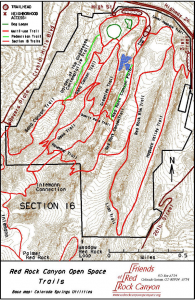 The map is from the Friends of Red Rock Canyon site. You can also get a PDF formatted map from the City of Colorado Springs site. The City map is more accurate.
Location
Red Rocks Canyon Open Space is located between Colorado Springs and Manitou Springs on the south side of US 24. The main entrance is the intersection of US 24 and Ridge Road: a half mile west of Highway 24 and 30th Street; a half mile east of the Manitou Springs exit on Highway 24.
Overview
The terrain is similar to Garden of the Gods. Lots of red rock outcroppings. It is not as dramatic as the Garden, but then there are no roads and few tourists.
The trails run from the north parking lots to the south. The north to south trails are about 1.5 miles long. There are east-west connectors, on several trails at or near the halfway point.
There is not much shade on the trails. Visit during the cooler parts of the day, and bring plenty of water and sun protection.
A Popular Place
Red Rocks Open Space is a favorite with all ages and abilities. It’s a great place for a family hike. It is great to see the kids on these trails. It is a great place for a moderately strenuous hike. Of course, the meaning of strenuous depends on what kind of shape you are in. Given that, it is a good place to get in shape.
On weekends the parking lots are always nearly full. So far I have never had a problem finding a parking space.
Trail Heads
Trail heads are accessible from three parking lots south of US 24:
- Two parking lots (west and east) are at the main entrance off Ridge Road and US 24.
- A third is on the east side of the open space on 30th Street.
I only discuss the trail heads accessed from the west and east parking lots off the main entrance on US 24.
The West Parking Lot Trailheads
The west parking lot (the first you pass on entering Red Rocks), gives access to two trail heads:
- The Greenleaf and Mesa Trails on the east side of the lot
- The Contemplative Trail on the west side of the lot.
The East Parking Lot Trailheads
The east lot, which is next to a picnic area, gives access to two trail heads.
- The Red Rock Valley Trail, at the south side of the lot.
- The Lower Hogback Trail at the east side of the lot.
Trails
#1: Red Rock Valley Trail/Red Rock Valley Path Loop
The Red Rock Valley Trail is the easiest in the open space. The first part goes from the east parking lot to the Quarry Pass Trail (about .7 mile ). It starts with a gentle rise and then is mostly flat. The round trip to the Quarry Pass and back is an easy, pleasant 1.5 mile hike.
As you leave the parking/picnic area at the trail head, you pass the construction area for a new visitors & and picnic area. These are next to two quarry ponds frequented by ducks and other birds.
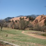 Just beyond the construction, a parallel trail, the Red Rock Valley Path bears off to the right. The Valley Path hugs the western wall of the canyon, and rejoins the the Valley Trail at the Quarry Pass Trail intersection. It is labeled intermediate on the map, but it is just as gentle as the Valley Trail which follows the left wall of the canyon.
Along both the Valley Trail and the Valley Path, steep Red Rock formations tower above the sides of the trail. These are frequented by technical rock climbers with their ropes and pitons.
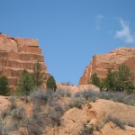 As you get near the Quarry Pass you have great views of the Section 16 trail area to the west. Beyond that you can see the mountains in the Cheyenne Canyon/Gold Camp Road area.
Together the Valley Trail and Valley Path make for a pleasant loop hike after you have spent some time at the Quarry Pass.
An alternative return route is to cross the Quarry Pass and follow the Greenleaf trail back to the parking lot. This is a rolling trail and is a little rocky in places. It is not a difficult trail. It is just not as easy as the Red Rock Valley trails.
#2: Red Rock Canyon/Red RockRim/Lower Hogback Loop
This is an extension of the Red Rock Canyon Trail beyond the Quarry Pass intersection.
After the Quarry Pass intersection, the Red Rock Canyon Trail gently rises for .25 miles to the intersection with the Red Rock Rim Trail.
The Rim trail loops east to the other side of the canyon wall, and meanders through a meadow for about 1.4 miles back to the parking lot/picnic area via the Lower Hogback Trail.
While the Rim Trail is labeled intermediate, and it has more of a rise than the Canyon trail, overall it is relatively easy. The total round trip back to the parking area via this route is about 2.4 miles.
#3: Red Rock Canyon/Roundup/Mesa Trail
This is another extension of the Red Rock Canyon Trail beyond the Red Rock Rim Trail intersection.
After the intersection with the Red Rock Rim Trail, the Red Rock Canyon Trail becomes a legitimate intermediate trail for about .15 miles. Then it flattens and ends at the intersection with the Round Up Trail.
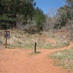 The Round Up Trail is labeled difficult on the maps, and for the most part this is true. It is a narrower path that winds through a beautiful wooded canyon and then rises quickly to the intersection with the Mesa Trail.
The first part of Round Up is easy and worth anyone’s time and effort. (You can turn back when the trail starts rising too much.)
Then the trail starts traversing a series of switch backs during a quick rise to the intersection with the Mesa Trail.
Once on the Mesa Trail you have about .25 miles of a moderately steep up hill climb to you get to the intersection with the Greenleaf Trail and the Section 16 Connector Trail. It is straight up. No switch backs or traverses.
Once you get to the Greenleaf Trail intersection, everything back to the parking lot is downhill. The scenery is beautiful. To the south you see the Section 16 trail area. Beyond that the Cheyenne Canyon area and Buckhorn Mountain. To the West the Manitou and Pikes Peak areas. To the North, Garden of the Gods and the Rampart Range. To the North East and East a panorama of the plains and Colorado Springs.
To get back to the parking area you can continue on the Mesa Trail or take the Greenleaf Trail. The Mesa Trail is a bit longer, but a smoother, gentler return route. The Greenleaf Trail is steep and rocky for about .4 mile to its intersection with the Quarry Pass Trail. From there on it is easier.
From the start of the Red Rock Canyon Trail, to the Mesa Trail/Greenleaf Trail intersection, is about 1.6 miles. It is about another 1.5 miles back to the parking lot by either the Greenleaf or Mesa Trails. The total round trip is about 3.1 miles.
Hike 4: Greenleaf Trail
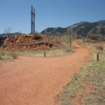 The Greenleaf Trail, from the west parking lot, to its intersection with the Mesa Trail and the Section 16 Connector Trail, is the most strenuous hike in the open space.
From the beginning of the trail, to the Mesa Trail fork, is a moderate rise. Then there is a downhill section, followed by another moderate rise to the Quarry Pass intersection.
At the Quarry Pass intersection you can go east, through the Quarry Pass, and catch the Red Rock Canyon Trail, or you can go west on a winding path that takes you up to the Mesa Trail.
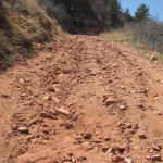 If you want a challenge, keep going on Greenleaf. The first part is steep and rocky. Then the trail levels out for a bit. Then the trail continues on a steady moderately steep rise until after .4 miles it reaches the Mesa Trail/Section 16 Connector Trail intersection. It’s my warmup before taking on more strenuous trails in Cheyenne Canyon and Section 16.